|
TABLE MOUNTAIN ORIENTATION
|
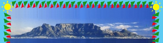
Surrounded by both the Atlantic and Indian Oceans and dominated by the majestic Table Mountain, the natural beauty of Cape Town is simply breathtaking.
|
|
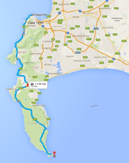
Cape Peninsula: showing the Atlantic Ocean to the west, False Bay (Indian Ocean) in the South-East; and 'greater' Cape Town, which includes the Cape Flats and Northern suburbs, in the East.
|
Table Mountain is the iconic, signature of Cape Town, with the city and suburbs developing around its slopes. The 'city bowl' is cradled in an amphitheatre, created by Devils Peak, Table Mountain, Lions Head and Signal Hill. The 'Southern suburbs' extend along its Eastern flank, all the way down to Muizenberg, where the mountain meets the Indian Ocean; and the 'Atlantic seaboard' extends along the Western '12 Apostles' of the mountain, to Llandudno and Hout Bay.
THE CAPE PENINSULA
| NORTH |
SOUTH |
WEST |
EAST |
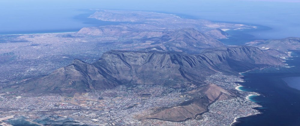 Table Mountain : From the North, looking South Table Mountain : From the North, looking South
|
Really, its a peninsula - a range of mountains, surrounded by sea, with the suburban areas nestled on the slopes between the mountain buttresses and the oceans. I prefer to think of it as an island; because if you imagine a tidal wave rolling in down the Atlantic coast, into Table Bay and washing the Cape Flats away, into False Bay, that's what would be left behind ... the Table Mountain range, as an island!
Wherever you are in Cape Town, the mountain is going to tower in front and above you. But it could get confusing, because wherever you are ... it never looks the same; which the views (above) from the North, South, West and East, will illustrate; if you click the link to see each view.
It's not a mountain that rises, straight up into the sky to a needle-like peak. This is a mountain, 270 million years old - really a range - extending from the northern point of the peninsula at Mouille Point, to Cape Point, 50 kilometres away 'as the crow flies' (75 km/1.5hr drive) and which features large, relatively 'flat' areas that are 800 to 1086m above sea level (ASL) ... hidden away on top of those large buttresses that you see from below.
And if you're up to it, there is no better way to experience the natural beauty of Cape Town, than up there, on foot. And here's what you'll find!
Hover your mouse over the map to see it in full-size, or click the map to see it full-size in a new window/tab.
KEY
w = white (man-made features)
g = green (waypoints)
y = yellow (waypoints)
TABLES
The red borders illustrate the relatively flat 'table'-top areas of Table Mountain.

|
|
Table Mountain : topology, features and paths.
|
- The two smaller areas directly above the city bowl, are the 'Western' and 'Eastern' tables, which are collectively referred to as the 'front' table. The front tables are between 1000-1086m, above sea level. The highest point of the mountain is Maclears Beacon (y9), on the Eastern table.
- The larger, 'horse-shoe' shaped area is the 'back' table, which is between 750-800m above sea level.
CONTOUR PATHS
There are two( light-blue) contour paths, by which you can cicumnavigate almost the entire mountain.
- The path along the front face of the mountain, called 'the Contour Path' starts at Kloof Corner (y2) and runs through Kings Blockhouse (y4), Kirstenbosch (y5) ends at Constantia Nek (y6).
- The other, shorter path called the Pipe Track, starts just above Kloof Nek (g1) and traverses many of the buttresses (Apostles) on the west side, before ascending to the top of the 'back' table (g2), via Corridor Ravine.
ROUTES
From either level countour path, a number of routes (dark-blue) enable you to ascend up onto the tables.
- India-Venster : starts just left of the Upper Cable Staton (w1) and ends at the top of Platteklip Gorge (g8).
- Platteklip Gorge : starts on the Contour Path (y3) and ends at g8.
- Smuts Track : starts at Kirstenbosch (y5) and ends at Maclears Beacon (y9).
- Skeleton Gorge : is a section of Smuts Track, starting at Kirstenbosch (y5) and ending at the back of the Hely-Hutchinson Dam (y7).
- Disa Gorge : starting at the deep-end of the Hely-Hutchinson Dam and ending on Smuts Track, at y8.
- From Valley of the Red Gods (g4) this path ascends from the 'back' table, via Echo Valley (g5), up to the top of Platteklip Gorge (g8) on the 'front' table.
- Bridle path : starts at Constantia Nek (y6) and reaches the 'back table' at the De Villiers Dam (w10). Much of this path is a concrete road, used by Nature Conservation to access remote areas of the mountain.
LEVEL PATHS (on top of Table Mountain)
On top of the tables, a number of (light-blue) level paths enable you to get to and explore, from one end to the other.
- g3-g4 : this is the 'Apostles' path, running from Hout Bay Corner (g3) to Valley of the Red Gods (g4). This path is quite undulating.
- g4-g6 takes you past some of the man-made structures on the 'back' table.
- g6-g7 : a concrete road that runs from the west into Disa Gorge.
- w10-g6 : a concrete road that brings you via the dams, from the eastern side.
- y7-g6 : from the top of Skeleton Gorge (y7), another level path brings you onto the concrete road.
- y9-g8 : on top of the Eastern table, a path from Maclears Beacon (y9) traverses the edge of the table to bring you to the top of Platteklip Gorge
- g8-y10 : Platteklip Gorge to the Upper Cable Station
FEATURES
All the white (w) markers are landmarks or man-made structures.
- Lower Cable Station
- Mountain Club Hut
- Scout Hut
- Nature Conservation
- Nature Conservation (Dam Overseer)
- Woodhead Dam
- Hely-Hutchinson Dam
- Victoria Dam
- Alexandra Dam
- De Villiers Dam
- LH - Lions Head
- DP - Devils Peak