
And this cultural history has developed against the backdrop of a natural history that is equally impressive and which makes Cape Town a city of uniquely spectacular natural beauty.
The city of Cape Town lies sprawled across a peninsula bounded by Table Bay and the Atlantic Ocean on one side and False Bay on the other side, influenced by the warmer Indian Ocean on the other (eastern) side. And the Table Mountain range extends from the city-centre at the northern end all the way to the Cape of Good Hope at the southern tip, some 50km away (as the crow flies).
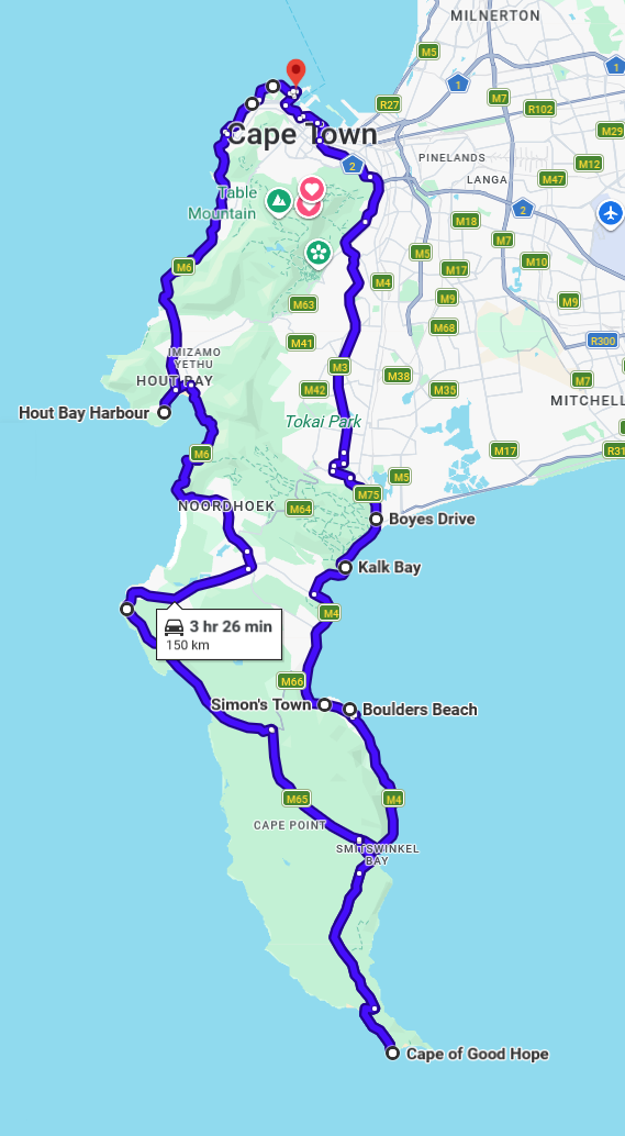
From the V&A Waterfront, you'll see the towering front face of Table Mountain and then Devils Peak, as the road takes you around the eastern corner of the mountain. From there you'll notice how the vegetation changes to forest along the eastern side, as you make your way over Wynberg Hill and into the Constantia Valley wine-making area. You've only been driving 20min and already you've seen all of that ...
From the far end of Constantia Valley, the high-level Boyes Drive provides a stunning panoramic view over False Bay and historical town of Muizenberg below you. There are tidal pools for swimming at St James and Dalebrook, before you reach the Kalk Bay fishing harbour where the village features many quaint arts and crafts stores, restaurants and entertainment.
As you follow the False Bay coastline, you'll drive through Fish Hoek, yet another beach with shallow, warm waters and picnic and sunbathing spots along Jager's Walkway. Then Glencairn and the naval base at Simonstown, before Boulders Beach to view the penguin colony.
The residential areas become sparse as you follow the coastline another 25km to the Cape of Good Hope, in the Cape Point Nature Reserve. Here you can see a variety of wildlife - Chacma baboons, Rocky Hyrax (Dassies), Eland, Bontebok Ostrich and Cape Mountain Zebra, as you make your way to visit the lighthouse which warns passing vessels of the treacherous 'Cape of Storms'.
You're only half-way now but this is as far south as you can go, so the road takes you west to the Atlantic Ocean on the western side of the peninsula, where you'll pass more sandy beaches as you drive through Scarborough, Witsands to Kommetjie and then Noordhoek.
You're staring out over the vast expanse of Atlantic Ocean, as the road - cut into the side of the mountain - climbs through the twists and turns, over Chapmans Peak drive; and climaxes 160m above the sea, at a spectacular viewpoint overlooking Hout Bay and the fishing harbour village.
Following various picnic sites, the road proceeds into Hout Bay where a variety of seafood options are available in the vibrant fishing harbour; as well as charter boats rides and entertainment from the local people.
There's not much left of your day but it's all equally spectacular, with the sun setting over the Atlantic on your left and the mountains above you on the right, as the road follows the coastline, back towards the city.
Lions Head comes into view then Table Mountain, as you come back into the residential areas of Bakoven and Camps Bay, where a line of palm trees marks the beachfront.
Bantry Bay, then Sea Point, following the promenade into Mouille Point, Granger Bay and then you're back in the city centre, or at the Waterfront - 150km and 9 hours of stunning natural beauty!
 You've spent a full day driving around this peninsula paradise and that day has given you a great introduction and overview of what Cape Town has to offer; now you can select what you'd like to explore more closely ... the beaches, the mountains, the historical places, the nightlife, the winelands ... Cape Town has it all!